After mapping it, I don't know if it would have saved you that much road distance but it is an alternative. Gonzales in on the north side of Carmel Valley Road. It is also directly behind Torrey Pines HS. There are a few fun trails in there.
| Dirt Treaders https://www.dirttreaders.com/phpBB3/ |
|
| Long local loop - coast to crest https://www.dirttreaders.com/phpBB3/viewtopic.php?f=20&t=16497 |
Page 1 of 1 |
| Author: | OhNooo [ Mon Aug 10, 2015 12:34 pm ] |
| Post subject: | Long local loop - coast to crest |
Hi Folks, I did some google maps snooping, and figured out a fun new (to me) local loop. It links up some parts of my area that I never tried linking before. Here's the summary of the path: 1 PQ canyon westbound. Bonus: I ran into a couple of buddies at the start of this, so I had someone to ride with for this segment. 2 Sorrento valley streets to get to Torrey Pines state beach (unavoidable road segment). 3 Ride the sand north until it ends at San Dieguito river outlet. Time the tides for this part. I was riding 2 hours after high tide which was perfect, as the sand was wet packing it down for ideal riding. 4 Get to 28th street where there's a passage over the tracks to get a running track to Jimmy Durante (very short road segment). 5 Cross the channel on the Jimmy Durante bridge to get to Coast-to-Crest trail. Ride that until it ends at the polo grounds. Eventually it is supposed to continue, but now it is only a few miles. 6 Cross into the polo grounds and ride the edge fire road until it dumps you out into a golf course. It's fine for a while but becomes a completely HAMMERED trail by thousands of horse hoofs. It's deep powder in spots so this is tough going. This section was harder to ride than the sand on the beach. 7 A tiny connector trail to get to San Dieguito road. This trail was clearly visible on Google maps, but almost invisible to find during the ride. It's very overgrown since that satellite photo. 8 3 miles of unavoidable San Dieguito road. If there's a way around this, I would love to know what it is. 9 Take the power lines fire road to connect to Lusardi canyon. 10 Play around on Black Mountain (Lilac and Ahwee), 11 Black Mountain road south (avoidable road that I chose because I was pooped) I broke my toe a couple of months ago, and I can finally get back on the bike now. But hike-a-bike is still quite painful. I can't put a lot of weight on my bent toe yet. Once I'm healed I'll change the ending to traverse Black Mountain in the other direction as Ahwee -> Lilac -> Miners Loop -> Nitehawk -> Sundevil. Then 56 bike path back to the start. That would eliminate a lot of the final road segment. Here's the tracks for those interested: https://connect.garmin.com/activity/860552467 |
|
| Author: | bankerboy [ Mon Aug 10, 2015 2:00 pm ] |
| Post subject: | Re: Long local loop - coast to crest |
Very nice job, Paul. An option to help reduce the road miles would be to include Gonzales Canyon at intersection of San Dieguito Road and El Camino Real. The first part would have been single track with some climbing but the eastern end towards Lusardi would have been DG sidewalks. Then you could have taken the western end of Lusardi into the canyon or just headed up to the BMOS ball-fields. Still, from one old guy to another, coming off an injury, with limited bike riding recently, that was a hell of a loop. Now, if we could only get the single track through the Torrey Pines preserve on the south side of the lagoon open to bikes (clearly marked as not), you would can avoid nearly all the street riding. |
|
| Author: | OhNooo [ Mon Aug 10, 2015 2:26 pm ] |
| Post subject: | Re: Long local loop - coast to crest |
Hi Matt, I'm not sure I know where Gonzales canyon is exactly. Is that the E-W canyon that is south of San Dieguito road? I can see a fire road in the bottom of a canyon that starts near the words "SEABREEZE AT OLD EL CAMINO REAL" in google maps. This extends east to Rancho Santa Fe farms. Then find a connector to get a bit further east to Via Abentura (at Evergreen nursery) and take that north. It turns into the power line fire road that gets to Lusardi. Is that the path you are talking about? The highlight of San Dieguito road was stopping off at the Rancho Santa Fe farmers market to check out all the surgically modified customers arriving in their Teslae. |
|
| Author: | bankerboy [ Mon Aug 10, 2015 3:44 pm ] |
| Post subject: | Re: Long local loop - coast to crest |
After mapping it, I don't know if it would have saved you that much road distance but it is an alternative. Gonzales in on the north side of Carmel Valley Road. It is also directly behind Torrey Pines HS. There are a few fun trails in there. |
|
| Author: | OhNooo [ Mon Aug 10, 2015 4:51 pm ] |
| Post subject: | Re: Long local loop - coast to crest |
Thanks Matt, If you only stay on Carmel Valley for only one block, you can head along a power-line fire road to get north to Lusardi. I think this is worth trying... But like all arrow straight power-line fire roads, this probably has some nasty elevation changes. 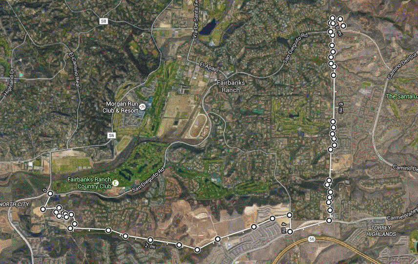
|
|
| Author: | bankerboy [ Tue Aug 11, 2015 4:31 am ] |
| Post subject: | Re: Long local loop - coast to crest |
an alternative to the fire road/powerpole service road along Evergreen since it heads deep into Fairbanks ranch where they shoot foreigners.... At the same intersection of Carmel Valley road and Evergreen nursery, head right, into the construction zone, along the same fire road/powerpole service road. It is on the outer edge of the construction so it should be open. Eventually, after all the construction is complete this will be the official connector to McGonigle(white line, sort of). For now, about 200 yards south of the intersection, look for a single track heading east towards a small grove of eucalyptus trees. Take that until it goes over a couple short drops leaving you on a service road just below the existing houses. Follow the service road down hill for about 50 yards and look for your left. The trail will stay below the edges of the homes. It will turn into a 6 ft wide DG "path" (better than pavement, right?) Eventually you pop out on Marker Rd. Follow it 300 yards to Torrey Del Mar and make a right. Make left on McGonigle Terrace and look for the resumption of the DG path (you can see this one to the north from the 56 as you cross over McGonigle canyon) In another 75 yards, be on the lookout for the single track that heads down hill, ultimately leading you under the 56 bridge. Watch out for the concrete drainage ditch at the bottom. Once you get under the bridge, you will need to HAB over the rocks and across the stream. This will lead you to the McGonigle canyon trail and from there you have PQ to the south/west and Black Mountain to the north/east. |
|
| Page 1 of 1 | All times are UTC - 8 hours [ DST ] |
| Powered by phpBB® Forum Software © phpBB Group http://www.phpbb.com/ |
|